Search results 1 Found
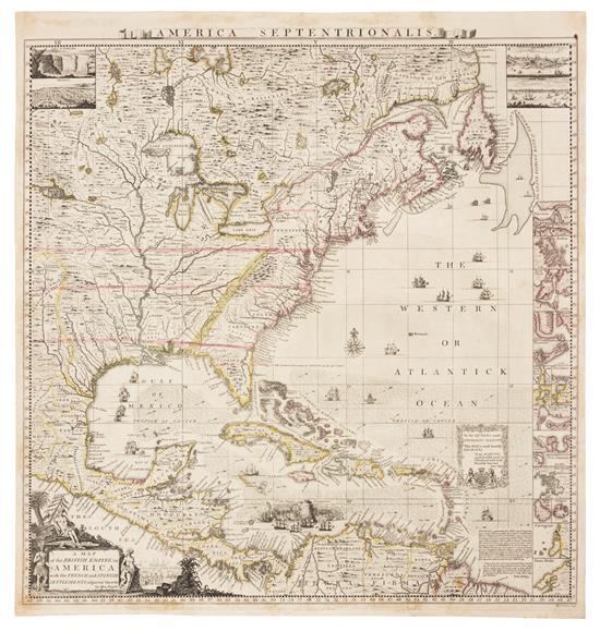
A Map of the British Empire in America with the French and Spanish Settlements thereto.
A Map of the British Empire in America with the French and Spanish Settlements thereto.
POPPLE, Henry (d. 1743)
- Publisher: London, ca. 1734
- Date published: 1734
- Format: Softcover
Engraved map hand-colored in outline (Image: 19 1/2 x 19 in.; 49.5 x 48.3 cm. Sheet: 21 x 20 in.; 53.3 x 50.8 cm), decorative cartouche depicting Native Americans and European settlers, insets of Niagara Falls, Mexico, Quebec, and New York, small insets of 17 harbors including Boston, New York, Charleston, and Porto Bello. BINDING/CONDITION: Floated on sturdy card stock and enclosed in mylar. One or two tiny tears in left margin, margins lightly toned. (65B1D) FIRST EDITION, BABINSKI'S FIRST STATE of Popple's key map: without imprint below border at lower left, imprint bottom right signed "W. H. Toms. Sculp.," with the course of the Spanish galleons not present, Cape May and Cape Hinlopen not named off Delaware Bay. This copy is like "most, if not all, colored copies [which] do not have the 4 corner views or the title cartouche at bottom left colored" (Babinski). The key map accompanied Popple's first large-scale map of North America printed on twenty sheets. PROVENANCE: Evelyn and Eric P. Newman (their sale, Leslie Hindman, 12 October 2018, lot 102) REFERENCE: Babinski, Henry Popple's 1733 Map of the British Empire in America Key Map
aradergalleriesaradernyc-12000.00-6c5984d998037c88d6e04c7b1ad5f3f6