Search results 4 Found
L'isole piu famose del Mondo.
L'isole piu famose del Mondo.
PORCACCHI, Thomaso
- Publisher: Heirs of Simon Galignani, Venice
- Date published: 1590
- Format: Hardcover
Small folio [20.25 x 29.5], (6) (of 12) ff., including engraved title, 201, (1) pp., including 47 copper plate engraved maps in text. Note: bound contemporaneously without 2nd half of index (b signature). Complete with all maps. Bound in contemporary flexible vellum, borders of covers gilt-ruled with arabesque in center, spine gilt with double bands. Head of spine chipped, and some soling to covers. Engraved ex libris of Thomas Heath, Merchant of Exeter and another of the Western Reserve Historical Society, stamped withdrawn. Some soiling in outer margin of title and scattered leaves, faint waterstain in margin of others. Notwithstanding a fresh copy with the maps in excellent impression. Excellent enlarged edition of one of the most beautifully engraved Italian island books of the sixteenth century. L'isole piu famose was the first with maps engraved on copper; and with the Gastaldi edition of Ptolemy¿s Geografia, 1548, it was among the few geographical works of any kind illustrated with engravings. This edition of Porcacchi contains much more than the first. According to Phillips Atlases it contains 17 maps not in the edition of 1572, including two relating to America: Jamaica and Puerto Rico, here called ¿Isola di S. Giovanni¿ for San Juan. Also included are maps of Spagnola and CUBA, Altogether, pages 154 to 184 relate to America. The volume closes with ¿Descrizione del Mappamondo¿ and ¿Discorso intorno alla carta da navigare,¿ pages 193 to 201, illustrated with two splendid Lafrerian-style maps of the world engraved by the Paduan Girolamo Porro. Porro, well-known as a book illustrator, later engraved maps for the first small-format Mercator atlas and for a Ptolemy (both appearing in 1596). According to Shirley, the oval-shaped world map ¿is a finely-executed reduction of Camocio¿s large world map of 1567, one of the last in the long line of derivatives from Gastaldi's prototype of 1546.¿ * Adams P-1906; Sabin 64105; Shirley 127-28; see The World Encompassed 86.
martayanlan-8500.00-34e2cf232419ca8a05affddfa5624e82
L'Isole Piu Famose Del Mondo. Con L'Aggiunta di Molte Isole.
L'Isole Piu Famose Del Mondo. Con L'Aggiunta di Molte Isole.
PORCACCHI, Thomaso.
- Publisher: Venice: Simon Galignani and Girolamo Porro, 1576
- Date published: 1576
Second and best edition, which contains "much more" (Sabin) than the first edition of 1572, including 17 additional maps. Two of these, Jamaica and Porto Rico, are in the eight-map section on the New World, which also includes a reduced version of Forlani's 1565 map, the first to show America as a single geographical entity, Temistitan (Mexico), Cuba, and others. The last two maps, "Descrittione del Mappamondo," and "Discorso intorno alla Carta da navigare" are "a finely-executed reduction of Camocio's large world map of 1567. [&] a nautical map covering most of the world" (Shirley). Both show a vast southern continent "terra incognita", and the latter is accompanied by a brief navigational text with information on winds and currents. The superb engraving is the work of the joint publisher, Girolamo Porro, Paduan artist-illustrator-engraver, who illustrated the 1584 Venice edition of Ariosto's Orlando Furioso and Porcacchi's Funerali antichi di diversi Popoli et Natione, and engraved maps for Magini's 1596 edition of Ptolemy's Geographia and Mercator's Atlas Minor of the same year. Two variants have been observed in the edition, but no priority between them has been established; the present copy has p. 13, line 10 ending 'mara' and line 11 beginning 'uigliosa'. Adams P-1905; Phillips 167; Sabin 64149; Shirley 127-28. Folio (285 x 198 mm). Near-contemporary limp vellum, renewed endpapers. Engraved title, and 47 half-page engraved maps by Porro after Poracchi, wood-engraved opening initials, head and tail-pieces, and printer's device at end. A hint of wear, small ink stains to bottom edge, renewed endpapers, light soiling, creases to bottom corner of ff. K3-4, pen trials to bottom margin of p. 58; still, a very good copy.
peterharrington-9674.03-2df04d7de9bf174898a64e60edd6f4d4
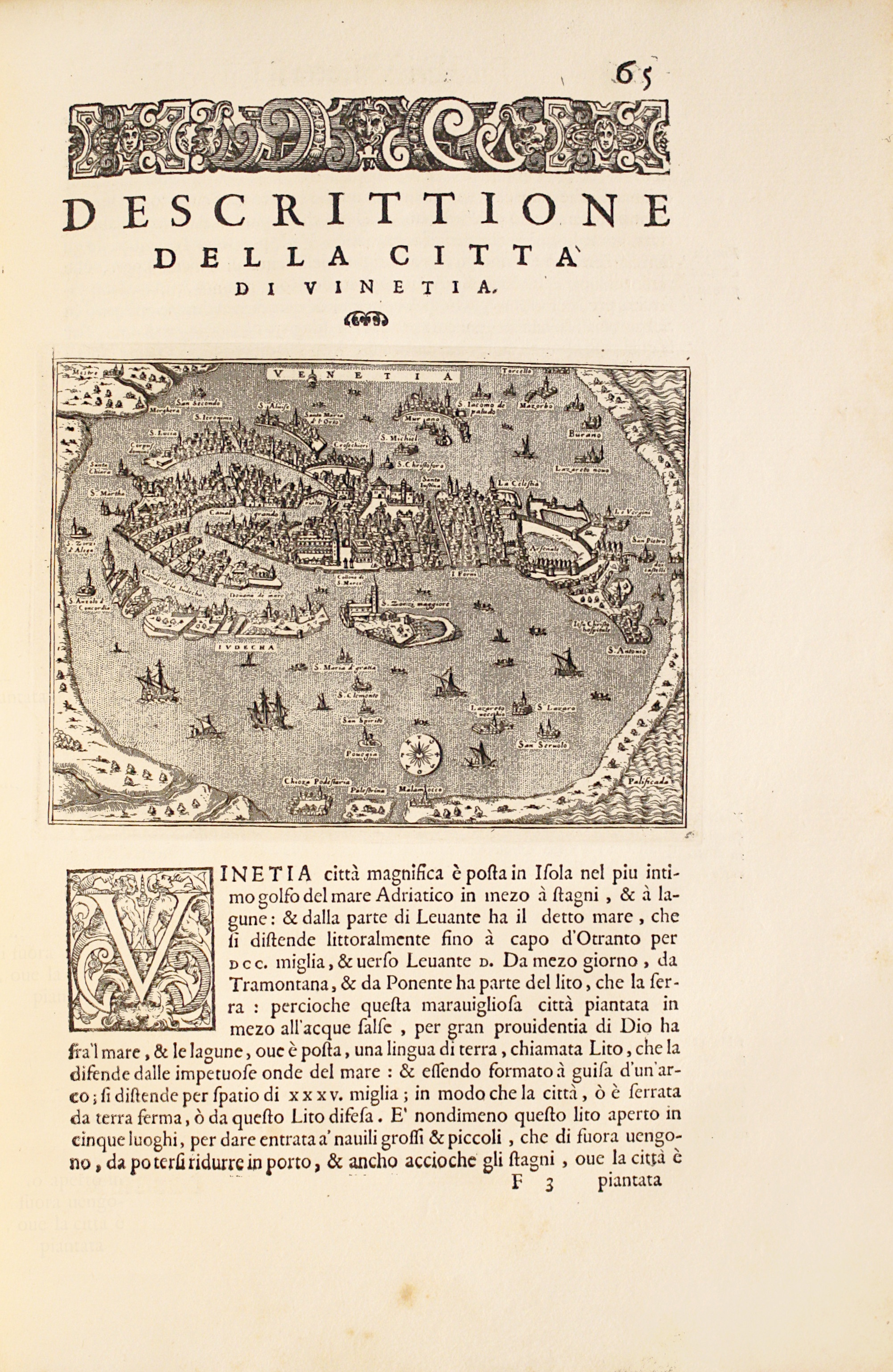
L'isole piu famose del Mondo. Arettino e intagliate da Girolamo Porro Padovano. Con l'aggiunta di molte isole all' ill.re s. conte Georgio Trivltio. - [THE CULMINATION OF THE "BOOK OF ISLANDS"]
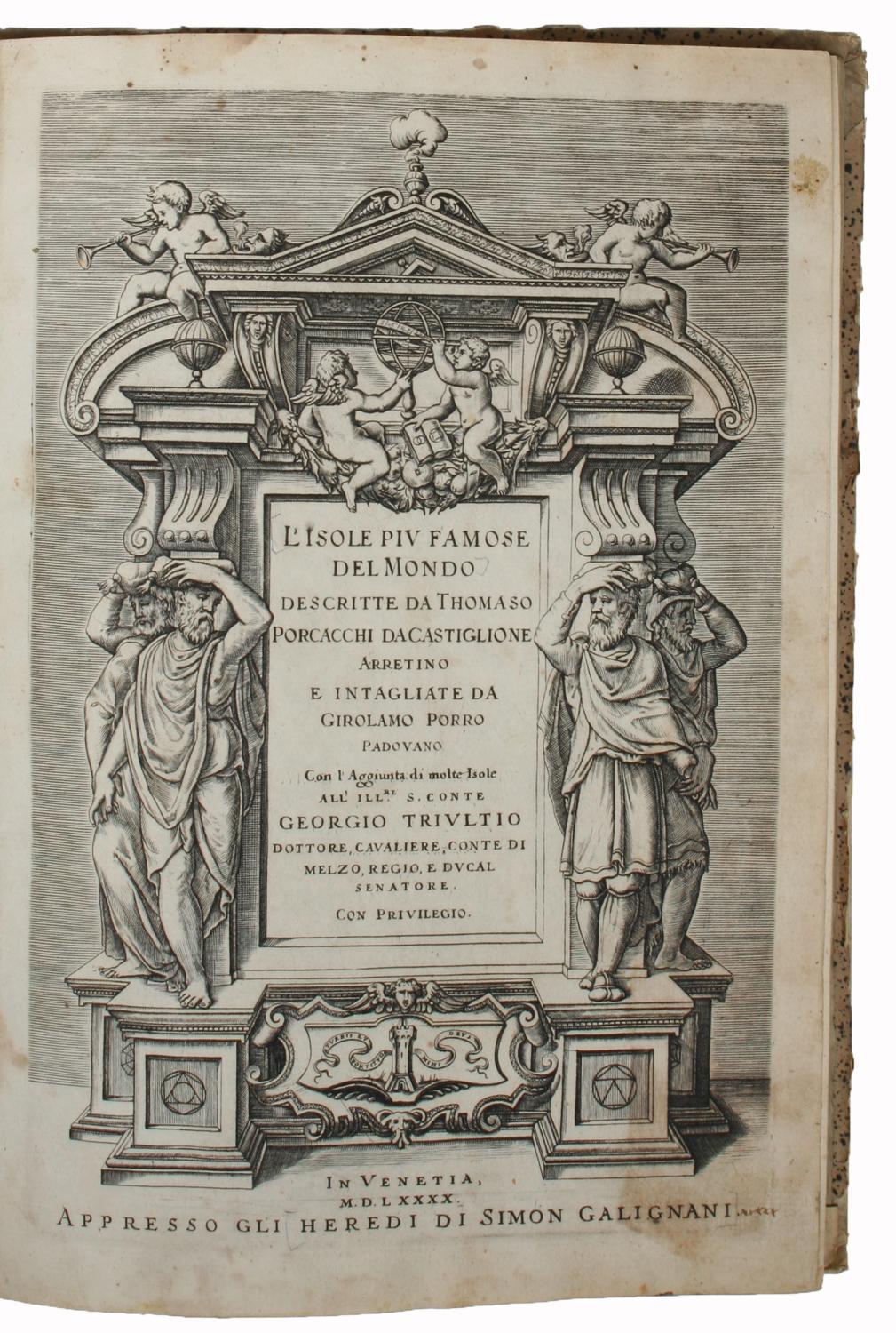
L'isole piu famose del Mondo. Arettino e intagliate da Girolamo Porro Padovano. Con l'aggiunta di molte isole all' ill.re s. conte Georgio Trivltio. - [THE CULMINATION OF THE "BOOK OF ISLANDS"]
PORCACCHI DA CASTIGLIONE, THOMASO.
- Format: Hardcover
Venetia [Venice], apresso gli heredi di S. Gagliani, 1590. [Colophon: In Vintia, appresso Giorgio Angelieri, a instantia de gli heredi di Simon Gagliani de Karera, 1590]. Small folio. 18th century (ab. 1780-90) half vellum with gilt leather title label to spine. Corners a bit bumped and title label a bit worn, otherwise nice and tight. A very nice copy, on thick, crisp paper. A few quires browned and brownspotted, and some occasional lighter browning. Four leaves with a marginal worm-tract, far from affecting text. Beautiful engraved title-page, consisting of a wide architectural border illustrated with large figures, putti, globes, and various symbols. Beautiful large woodcut initials and head- and tail-pieces. 47 half-page engraved maps in the text (by Porro, of islands and continents), excellent, crisp impressions. Large woodcut device to colophon. (12) ff., 201, (1) pp. Third, much enlarged edition (with 47 maps as opposed to the mere 30 of the first edition) of Porcacchi's great book of islands, arguably the most famous of all "isolario"s, with the 47 finely engraved maps by the famous map-maker Girolamo Porro, which also include maps of non-insular places, e.g North America and Mexico City, the famous city plan of Venice and that of Constantinople. Porcachhi's great "isolario" represents the culmination of the "book of islands"-genre, both in regards to artistic quality and the information provided. It furthermore constitutes a main work in the history of the published knowledge of farther parts of the world and an important link in the development from what we call the "book of islands" to the modern atlas. As such it is of great value in several respects, both historically, culturally, and cartographically. "The "book of islands," or isolario, a novel form of cartographic book combining maps and narrative-historical chorography, was invented and initially developed in Italy during the fifteenth and sixteenth centuries. According to R.A. Skelton, "like the portolano, or pilot-book, to which it was related, it had its origins in the Mediterranean, as an illustrated guide for travelers in the Aegean Archipelago and the Levant.". The first "book of islands" was authored by a Florentine ecclesiastic [around 1420] named Cristoforo Buondelmonti [.].The "book of islands" was eventually superseded as a cartographic genre, as was the "Geographia" of Ptolemy, by the modern atlas" it persists even after Abraham Ortelius's 1570 "Theatrum orbis terrarium", but at the margins rather than at the center of the history of cartography. While the "isolario", Ptolemy's "Geographia", and the "modern" atlas coexist for some time, the gradual eclipse of the "book of islands" at one level reflected a progressive decentering of the Mediterranean that occurred within the broader context of early modern history, following the Atlantic discoveries. But well before that happened, in conjunction with the culminating moment of the discoveries and exploration period and at the height of the high Renaissance, the second printed "book of islands" appeared in 1528 in Venice published by Zoppino: the "Libro di Benedetto Bordone nel qual si ragiona de tutte l'isole del mondo" [Book of Benedetto Bordone in which are discussed all the islands of the world]. As the title suggests, this "isolario" provided even broader coverage than the Martellus recensions of Buondelmonti and gave special prominence to the islands of the New World [.].Da li Sonetti's translation of Buondelmonti's "book of islands" into a cycle of sonnets in Venice represented in its way an expression of the same desire to reconcile contemporary geographical knowledge to Italian vernacular traditions of geographical poetry that Berlinghieri's poetic Ptolemy expressed. But while the tradition of Tuscan geographical poetry would not survive the Quattrocento, the prose book of islands did, thanks especially to the Venetian print culture that was responsible for da li Sonetti and that produced Bordone's High Renaissance print "isolario". As mentioned, the print genre "book of islands" would endure in fact, albeit at the margins of modern cartography and literature, in multiple editions of Bordone, which were followed by the no less successful Tommaso Porcacchi's "L'isole più famose del mondo" (1572" with copper-plate engravings), a line that continued through the seventeenth century [.] But just as with other major literary fields of endeavor including the political (Machiavelli), the pastoral (Sannazzaro), the courtly-bureaucratic (Castiglione), and the epic-novellistic (Ariosto), the "isolario" produced its masterpieces in the discoveries and travel writing field(alongside Columbus, Vespucci, and Verrazzano) during the High Renaissance." (Cachey, "From the Mediterranean to the World: A Note on the Italian "Book of Islands" ("isolario")", pp. 1-10). Shirley T.POR-1d" Phillips: 50.
lyngesnabf-11153.28-f2b6602108983a9ba5b0aa5a8973a783
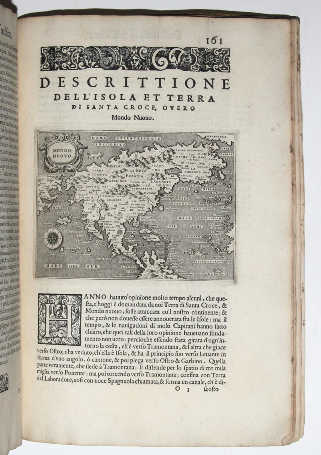
L'Isole piu famose del Mondo.
L'Isole piu famose del Mondo.
PORCACCHI, Thomaso
- Date published: 1590
- Format: Hardcover
Venetia, Heredi di Simon Galignani, 1590.In-folio de (3) ff.bl., (12) ff., 201 pp., (1) p., (1) f.bl. Un frontispice gravé, 47 cartes sur cuivre et la marque de l'imprimeur à la fin. Qq. ff. piqués. Conservé dans son vélin souple de l'époque à petits rabats, dos lisse avec quelques manques, titre manuscrit sur la tranche inférieure. Reliure de l'époque.310 x 214 mm. --- Troisième édition largement augmentée de ce célèbre atlas, illustrée de 47 cartes soit 17 de plus que dans la première de 1572. Leclerc, Bibliotheca Americana, n°461 ; Sabin 64150 ; Adams 1906. Les pages 157 à 184 sont consacrées à l'Amérique et contiennent « Descrittione della Gran Citta e isola Temistitan » et « Descrittione dell'Isola et terra di Santa Croce, overo Mondo Nuovo » avec une version réduite de la très importante carte de l'Amérique du Nord publiée par Forlani à Venise en 1565, la première carte à montrer l'Amérique comme une entité géographique à part entière, et la seconde carte à montrer de manière détaillée le détroit d'Anian. Ces pages présentent encore les descriptions d'Haïti, de Cuba, de la Jamaïque, de S. Iacopo, de S. Lorenzo, de S. Giovanni avec 5 cartes. L'ouvrage s'achève sur « Descrittione del Mappamondo » et « Discorso intorno alla Carta da navigare » pp. 193-201 avec 2 cartes du monde. La majeure partie des textes consacrés ici à l'Amérique parait ici pour la première fois. Cette troisième édition comporte 2 cartes qui paraissent ici pour la première fois, absentes de la seconde édition de 1576 : « Descrittione dell'Istria » et « Descrittione dell'Isola d'Elandia, isola de Gotti ». L'illustration comporte 1 titre imprimé dans un cadre architectural orné de symboles cartographiques, la marque de l'imprimeur au verso du dernier feuillet, et 47 cartes finement gravées sur cuivre. Les 47 cartes de Girolamo Porro, célèbre /// Venetia, Heredi di Simon Galignani, 1590.Folio [310 x 214 mm] of (3) bl.ll., (12) ll., 201 pp., (1) p., (1) bl.l. An engraved frontispiece, 47 copper engraved  maps and the printer's mark at the end. Some slight foxing. Preserved in its contemporary limp vellum with small flaps, flat spine with small portions missing, handwritten title on the lower edge. Contemporary binding. --- Third edition widely enlarged of this famous atlas, illustrated with 47 maps, that is to say 17 more than in the First edition of 1572. Leclerc, Bibliotheca Americana, n°461; Sabin 64150 ; Adams 1906. Pages 157 to 184 are dedicated to America and contain « Descrittione della Gran Citta e isola Temistitan » and « Descrittione dell'Isola et terra di Santa Croce, overo Mondo Nuovo » with a reduced version of the very important map of North America published by Forlani in Venice in 1565, the first map to show America as a geographic entity of its own, and the second map to show in details the Strait of Anian. These pages also present the descriptions of Haiti, Cuba, Jamaica, of S. Iacopo, S. Lorenzo, S. Giovanni with 5 maps. The book concludes with « Descrittione del Mappamondo » and « Discorso intorno alla Carta da navigare » pp. 193-201 with 2 world maps. The greater part of the texts dedicated here to America is published here for the first time. This third edition contains 2 maps that are published here for the first time, absent from the 1576 second edition: « Descrittione dell'Istria » and « Descrittione dell'Isola d'Elandia, isola de Gotti ». The illustrations consist of 1 title printed in an architectural border decorated with cartographic symbols, the printer's mark at the back of the last leaf, and 47 finely copper-engraved maps. The 47 maps of Girolamo Porro, a famous member of the Italian School, are superbly drawn. An attractive pure copy particularly wide margined (height: 310 mm), one of th
librairiecamillesourget-13867.00-34e2cf232419ca8a05affddfa5624e82