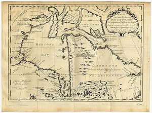
About this Item
Antique print, titled: 'Karte von der Hudsons Bay und Strasse.' - Map of the Hudson Bay and Strait. Etching / engraving on hand laid paper. Watermark: Text Description: From: 'Allgemeine Historie der Reisen zu Wasser und Lande; oder Sammlung aller Reisebeschreibungen […]', volume 16, by Johann Joachim Schwabe, published in Leipzig by Arkstee und Merkus, 1758. This series was published 1747-1774 in 21 volumes. It is essentially an enlarged German ed. based on and translated from 'New general collection of voyages and travels [.] (4 volumes, 1745 1747), by Thomas Astley and 'Histoire Generale des voyages [.] (20 volumes, 1746 1791), by Abbe Prevost.Artists and Engravers: Made by an anonymous engraver after 'Jacques Nicolas Bellin'. Jacques-Nicolas Bellin (1703-1772) was a French hydrographer, geographer and member of The Philosophes. His career, spanning over 50 years, caused an enormous output in maps, particular of maritime interest. Author: Johann Joachim Schwabe (1714 -1784) was a German academic, poet and translator. Condition: Very good, given age. Original folds as issued. Small stain in right lower of print. General age-related toning and/or occasional minor defects from handling. Please study scan carefully. Storage location: C143-43 The overall size is ca. 12.7 x 9.5 inch. The image size is ca. 11.6 x 8.4 inch. The overall size is ca. 32.3 x 24.2 cm. The image size is ca. 29.4 x 21.3 cm. Seller Inventory # 60065
Bibliographic Details
Title: Antique Print-NORTH AMERICA-USA-HUDSON ...
Store Description
Payment Methods
accepted by seller
PayPal Bank/Wire Transfer