Search results 2 Found
A Map of the British Empire in America with the French and Spanish Settlements thereto.
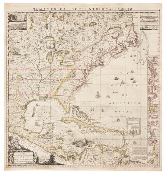
A Map of the British Empire in America with the French and Spanish Settlements thereto.
POPPLE, Henry (d. 1743)
- Publisher: London, ca. 1734
- Date published: 1734
- Format: Softcover
Engraved map hand-colored in outline (Image: 19 1/2 x 19 in.; 49.5 x 48.3 cm. Sheet: 21 x 20 in.; 53.3 x 50.8 cm), decorative cartouche depicting Native Americans and European settlers, insets of Niagara Falls, Mexico, Quebec, and New York, small insets of 17 harbors including Boston, New York, Charleston, and Porto Bello. BINDING/CONDITION: Floated on sturdy card stock and enclosed in mylar. One or two tiny tears in left margin, margins lightly toned. (65B1D) FIRST EDITION, BABINSKI'S FIRST STATE of Popple's key map: without imprint below border at lower left, imprint bottom right signed "W. H. Toms. Sculp.," with the course of the Spanish galleons not present, Cape May and Cape Hinlopen not named off Delaware Bay. This copy is like "most, if not all, colored copies [which] do not have the 4 corner views or the title cartouche at bottom left colored" (Babinski). The key map accompanied Popple's first large-scale map of North America printed on twenty sheets. PROVENANCE: Evelyn and Eric P. Newman (their sale, Leslie Hindman, 12 October 2018, lot 102) REFERENCE: Babinski, Henry Popple's 1733 Map of the British Empire in America Key Map
aradergalleriesaradernyc-12000.00-6c5984d998037c88d6e04c7b1ad5f3f6
Map of the British Empire in America with the French and Spanish Settlements adjacent Thereto.
Map of the British Empire in America with the French and Spanish Settlements adjacent Thereto.
POPPLE, Henry (d. 1743).
- Publisher: London: Henry Popple, 1733.
- Date published: 1733
- Format: Hardcover
Folio. Original RARE letterpress contents leaf (Babinski State 1, with incorrect enumeration of sheet 13 as XII) laid-down on the front paste-down. Fine engraved double-page "key" map with original hand-colour in outline and mounted on guard (to neat line: 19 6/8 x 19 1/8 inches; Brabinski State 1, circa 1734/35), 15 exceptionally fine engraved double page and 5 single page sheet maps by William Henry Toms. Modern quarter calf over contemporary marbled boards (extremities worn, surface tears and stains). THE FIRST LARGE-SCALE PRINTED MAP OF COLONIAL NORTH AMERICA Babinski's State 6 circa 1735, still sold by Henry Popple (Babinski, p.11) with engraved sheet numbers added in the upper right corners of each sheet distinguishing it from the preceding State 5; also lacking, as called for, the Toms & Harding proprietors imprint with detailed pricing below the bottom border on sheet 17. Henry Popple's Map of the British Empire in America marks the beginning of a new epoch in the mapping of America, and was the first in a series of maps published up to the 1760s that would catapult England to the forefront in the study of the geography of the continent. Commissioned by the Lord Commissioner of Trade and Plantation, it was intended as a tool for mediating disputes arising from the competing claims of English, French and Spanish colonists. In the years when this map was made, territorial disputes demanded current and precise geographical knowledge, and copies of Popple's map were sent to the governors of each English colony for official use. The map illustrates the growth of knowledge about the interior of the American Northeast, and there is much information regarding settlements and natives in the areas of the Great Lakes. Popple's map is a compilation of French and English sources, primarily Guillaume Delisle's "Carte du Canada" 1703 and "Carte de la Louisiana et Cours du Mississippi" 1718; , as well as the maps of Herman Moll. The most valuable contribution is in the area of the American Southeast, where the map incorporates information from the highly important survey by Colonel John Barnwell, circa 1722, which was the first detailed English map of the southern frontier. Information for the printed map was compiled at least as early as 1727, a date that appears on a signed manuscript draft by Popple now in the British Museum, although the actual draftsman of the final map was Clement Lempriere, an English military cartographer who worked in the Corps of Engineers. Of the four inset views, two are of special note. The first, of New York City, is an early copy of William Burgis's "South Prospect of the Flourishing City of New York," circa 1720. A second perspective view, of Quebec, is based on the manuscripts of Franquelin Joliet, which were previously published in French maps by De Fer and Châtelain. Seventeen detailed charts depict major islands and ports on the American coast and in the Caribbean. Boston, New York and Charleston are included, the latter based on the important inset to Edward Crisp's map of 1711. Numerous legends note historical and topographical features, including the route of Spanish fleet through the Bahama Channel and a vignette depicting the engagement of Sir Charles Wagner against the Spanish off Cartagena. Originally advertised for issue by subscription as early as 1731, Popple's map was not published until December of 1733. made poor sales, largely because of the exorbitant price of 4 pounds and 4 shillings, and only 16 copies of this issue are located in institutions worldwide, as opposed to 35 copies of the later Toms and Harding issue of August 1739 with a cheaper price of 1 pound, 11 shillings and 6 pence, after which the contents leaf and the "key" map were altered. The "key" map was not available until after the earliest issues of the map, having been engraved as a direct response to the difficulties faced by clients in assembling the unnumbered sheets. 6.4F.8E
aradergalleriesaradernyc-190000.00-d3ba49deb8377fe5cc07fc34ddbd3038